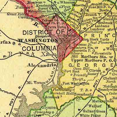
The District of Columbia, the seat of the federal government of the United States, is not a state but a federal district. It is situated on the Potomac River, and is bounded on the west by Virginia, and on the north, east, and south by Maryland. It lies between about 38º 48′ and 38º 59′ north latitude, and between 76º 56′ and 77º 7′ west longitude. The district measures about 10 miles square, though the present boundaries encompass 68 square miles, or 43,520 acres, after the portion originally ceded by Virginia was returned in 1846.
This state project is part of the much larger American History & Genealogy Project or better known by the abbreviation of AHGP. It has been in existence online since 2000 and over the years has been spread out across the web. These pages are an attempt to consolidate it under one website of the larger project.
District of Columbia Information
- District of Columbia
A complete descriptive and statistical gazetteer of the United States of America, By Daniel Haskel, A. M and J. Calvin Smith, published by Sherman & Smith, 1843. - Historical Dictionary of District of Columbia
- List of Principal Municipal Authorities of the Cities of Washington, Georgetown and the District of Columbia
- Street Nomenclature of Washington City
District of Columbia History
- Historic Fort Washington on the Potomac
- Hotels of Washington DC Prior to 1814
- Military forts of District of Columbia, 1903
District of Columbia Genealogy
- Evangelical Lutheran Church History and Membership
- Grand Masters of the District of Columbia Jurisdiction, 1814-1911
- Officers and Roster of Members, Second Army Corp Association
- Roster and Muster Roll of John F. Reynolds Post, 1891
- Society of Sons of The Revolution – The District of Columbia, Membership Roll, May 1891
District of Columbia Communities
Back to: American History & Genealogy Project