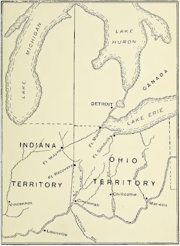
Division of the Northwest Territory
The next
movement in the evolution of the territorial divisions of the
Northwest Territory, was the act of Congress dated May 7, 1800.
This provided for the separation of the western part of the
territory, and calling it the Indiana Territory. The division
was to be at a line beginning on the Ohio opposite the mouth of
the Kentucky river; thence northerly to Fort Recovery; and
thence north to an intersection of the territorial line between
the United States and Canada. This line divided the lower
Michigan peninsula into two nearly equal parts, but it did not
remain in force for any considerable time. The eastern division,
thus created, was to remain under the existing government, and
the western division to be organized under a similar one.
It was also
provided in the act, that when the eastern part should be formed
into a state, the western boundary line should be changed, and
begin at the mouth of the Great Miami River, and run thence due
north to the Canada line. A division of the territory into
states had been contemplated in the Ordinance of 1787, and this
provision for changing the western boundary, made the act
coincide with the terms of the Ordinance upon the subject. Its
requirements were:
'There shall
be formed in the said territory, not less than three, nor more
than five states ; and the boundaries of the states, * * * shall
become fixed and established as follows, to-wit: The western
state in the said territory shall be bounded by the Mississippi,
the Ohio and Wabash Rivers; * * * the middle states shall be
bounded by the * * * line from the Wabash and Post Vincents due
north to the territorial line between the United States and
Canada, and by the said territorial line to
Map Showing Division of
Northwest Territory
the Lake of
the Woods and Mississippi, by a direct line drawn due north from
the mouth of the Great Miami to the said territorial line, and
by said territorial line. The eastern state shall be bounded by
the last mentioned direct line, the Ohio, Pennsylvania and the
said territorial line; provided, however, and is further
understood and declared, that the boundaries of these three
states shall be subject so far to be altered, that if Congress
shall hereafter find it expedient, they shall have authority to
form one or two states in that part of the said territory which
lies north of an east and west line drawn through the southerly
bend or extreme of Lake Michigan; and whenever any of the said
states shall have sixty thousand free inhabitants therein, such
state shall be admitted, by its delegates, into the Congress of
the United States, * * * and shall be at liberty to form a
permanent constitution and state government."
The census of
1800 revealed the fact that the eastern division of the
territory had a population of forty-two thousand, and although
this was less than the number set in the ordinance, to entitle
it to admission to the Union, the people were ambitious to form
a state government, and made application to Congress for the
privilege. Much scheming was indulged in at the time, between
the adherents of the Federalist and the Anti-Federalist parties,
each desiring to get the political advantage of the other in the
formation of the new state. Each desired to have the boundaries
coincide with their political majority. St. Clair was a
Federalist and was working for a state that would vote for his
party. He advocated that one be made from the territory east of
a line running up the Scioto' to the southwest corner of New
Connecticut, as, in this district, a majority of the voters
supported the Federal party. But in the boundaries, as they were
fixed in the Ordinance of 1787, not including the county of
Wayne, there was a majority in favor of the Anti-Federalists.
Congress was then an Anti-Federalist body, and the Ordinance
boundaries were left intact.
Online Resources
|
Ohio AHGP

Source: Ohio Archaeological and
Historical Publications, Volume 5, John L. Trauger, 1898.
|